August 2023 Digital Edition
In This Issue
Mapping Hurricane Idalia
Google Maps APIs help map environmental information
I/NAV improvements now available to Galileo Open Service users
Faux signals for real results: IFEN
Hexagon updates Puerto Rico and U.S. Virgin Islands aerial imagery and elevation mapping data
Faux signals for real results: Safran Federal Systems
Launchpad: Laser scanners, rovers and PNT devices
First Fix: Satellites and spacetime
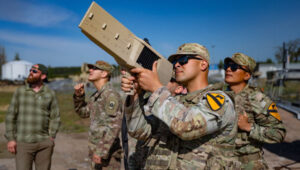
Defending America and saving lives with NITRO
Advancing geomatics tradecraft and education in the public interest
Thales partners with ESA on Galileo cybersecurity and enhancements