No audio available for this content.

I was born in a small town and I live in a small town. I’ll probably die in a small town, but only if you want to call a blue-collar city of 75,000 people small. My friends are small town and my parents still live here in this same small town. It was here in this small town that I started my career as a surveyor and circled back for an opportunity to be near family and friends.
There are many towns, villages and cities in the Midwest that fit this description — mostly because of the agricultural background, but also because of the labor-intensive industries that provide most of the local jobs. Like those who prefer the large city hustle-bustle lifestyle, the small town attitude is the same, but in the opposite direction.
My career as a surveyor has provided me with opportunities to work in both small and heavily populated areas. I have seen the definite distinction between the two environments, and have seen many of the technological advancements of the past few decades. Having worked in both the large urban multi-discipline engineering firm and the small town surveying firm, I see much disparity between how surveying is done today from varying firms. The biggest difference I see today is how surveyors are using GPS technology for their field operations.
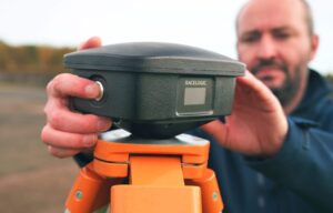
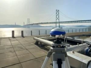
For the modern surveyor, GPS has become an everyday tool for measuring and data collection, but it wasn’t always that way. I began my career in the early 1980s working for a seven-person engineering firm in my small town, so GPS was never in our budget. Like most surveyors, I read about GPS use in technical publications, and was amazed what these magical boxes could do. The first generations of static receivers produced were very complicated and expensive. With long occupation times and even longer processing times, only the few companies who could afford the high-priced equipment and software were buying these units. Our small-town market could not justify this purchase, so we made do with conventional equipment as the norm.
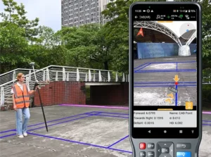
Today’s environment requires the working knowledge of handheld data collectors that are more powerful than the computer on the Apollo moon mission, laser scanners that collect millions of points per second, and GPS receivers that talk through cell phones to get sub-centimeter accuracy. Around the corner is wider use of lidar data collection as well as the unlimited use and application of UAVs with cameras and scanners, so there is no end in sight for technology and the surveyor.
Most of the larger urban firms have established equipment and training budgets stay current with technology and not lose ground with the competition. Because of these strategic and spending plans, fee structures have increased over the years, and thus the cost of surveying has increased accordingly. This has also afforded those who stay up-to-date with current technology to push the limits of the equipment, and to continue to find new and useful ways to perform our work and provide newer services.
By keeping their costs down, small-town and rural surveyors have kept their fees down as well, but to the detriment of the profession. In fact, the cost of a typical land survey in a small town has come nowhere close to inflation for the past 40 years in most places.
In comparison, however, many industry partners of the surveyor have spent a great deal of money and time staying current with technology and production methods. Excavators and earth movers now have GPS-based computers controlling their movement and placement of material, as well as utilizing robotic instruments and GPS for layout of improvements and utilities. Architects and structural engineers are utilizing scanners for building and piping as-builts for existing and future improvements. Almost all farmers have tractors equipped with GPS-based control systems to help them plant and harvest with pinpoint accuracy, as well as apply herbicides or pesticides based upon high-tech mapping performed by crop analysts. Many land-management companies are gearing up with UAV technology to assist future operations with the information gathered by these flying wonders. Everyone around us is tech savvy, but the small surveyor seems to lag behind.
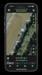
I wanted to be exposed to new technology when I moved from a small town to a large urban city in 1998. The big improvement for the surveying community was the introduction of real-time kinematic (RTK) methods. The firm I worked for during the late 1990s and early 2000s had been using RTK systems since their introduction. Being able to collect points “on the fly” both manually and with ATVs greatly increased our productivity as well as accuracy.
By the mid-2000s, almost every big-city firm utilized this technology as standard equipment for their crews. The only drawback to the RTK system was the need to leave a base-station receiver, so the introduction of the real-time network via cellphones in large market areas was another step in solidifying GPS use for everyday work.
Another benefit of extensive GPS use in the large city area is that most of the firms keep their surveys on state plane coordinate systems, so exchange and verification of data is a much easier process. These larger urban firms also continue to upgrade to newer equipment as more satellite systems are introduced. The addition of GLONASS has increased our precision and coverage levels, with future systems including Galileo, IRNSS and BeiDou set to raise that bar even higher.
On the contrary, many firms in small-town and rural areas have not progressed into new technologies because of cost and lack of cellular coverage needed for RTN systems. I moved back to my small town several years ago and have experienced this slip in technology firsthand. The big cellular carriers say they have 3G and 4G service in most places, but I can tell you from my travels that there are many places I have not been able to use our RTN receiver because of lack of cell signal. Most of the surveyors in our area still utilize an RTK system and will establish a position through OPUS or will assume a local coordinate system. Not many have upgraded their equipment to take advantage of GLONASS, so there are several steps they will need to take in the future to catch up to the industry. We also must travel greater lengths to recover NGS monuments for our positional verification, which will become more important as static monuments become a thing of the past.
So with my apologies to Mr. Mellencamp, my job as a surveyor has not been just small town, and has provided me with many big-city opportunities. Our crews face challenges here every day that many take for granted while in the big city market, including RTN coverage, GLONASS constellation usage and many more NGS monuments for QA/QC. Having more of these items could greatly help our productivity, especially when stronger cellular coverage is expanded to more of our rural areas.
I look forward to these improvements but will continue to work with our existing systems until that time. So look for us, surveying on in our small towns and locating all those little pink houses.
This column introduces Tim Burch, GPS World’s new co-contributing editor for survey. Tim will alternate with Dave Zilkoski in contributing monthly columns to the Survey Scene e-newsletter. Tim is survey department manager for Chastain & Associates LLC in the Decatur, Ill., area. He has been working as a professional land surveyor since 1985, and is the secretary, Board of Directors, National Society of Professional Surveyors.
For his next column in January, Tim plans to write about farmers and their technology in his area, focusing of course on GPS use. His article will compare surveyors’ processes with those used by farmers. (For Dave Zilkoski’s last column in October, see Establishing Orthometric Heights Using GNSS — Part 3.)
Contact Tim via editor@gpsworld.com.


Matthew Ericson
I’ve shared an almost identical experience in my time as a surveyor. While working for my a local Civil Engineering and Surveying company, my experience with anything other than an auto level and basic total station was virtually nonexistent. In fact, I had never operated a GPS (GNSS) receiver on my own until I went back to school in the mid-2000s. Our company performs a majority of small boundary determination surveys as well as a fair share of topographic surveys for the civil engineers to play with. I don’t know if it’s specific to our locality, but (from my experience) we have been forced to keep overhead minimal as job estimates also have to be minimized – if we were to charge any more than we already do, our competitors will severely undercut us and steal all of our clients. As I see it, the surveying industry has definitely NOT kept up with inflation as the author of this article states. This has serious repercussions in that our company simply can’t afford to modernize! They do now own a simple RTK-only GNSS receiver, but only one and it has minimal features. Unfortunately, I don’t see too much of a future in our company’s land surveying. As they can’t afford to modernize, I see two things inevitably happening: 1) other, larger companies will implement means of performing the work we do for less money and less time and 2) new, educated survey technicians will not seek employment with us as we don’t use the equipment they’re familiar with.
However, if I were to regain interest in surveying, I would love to return as head of surveying and implement modernized approaches at a relatively low cost that would help to turn things around. We could use UAV technology, advanced GNSS (including PPP), and remote sensing (Lidar, laser scanning, etc.) to perform the same tasks we currently offer with total stations and levels. Additionally, we could create new specialties other than basic topographic surveying and boundary work that would gain us a much larger clientele. The only problem with all of this is that I will never have a land surveying license due to the current requirements for additional field experience. Without a license, I would be extremely limited in my involvement in the company. The reason I mention this is because nearly all surveyors in my state (and most likely the rest of the country) are not educated to use these new tools and procedures. Back home, the licensure process is antiquated and focuses on use of “old school” equipment and procedures. Therefore, most surveyors never seek to learn new skills as they aren’t required to in order to maintain their licenses. As an aside, the “continuing education” system for surveyors in my home state is quite lacking. So, unless the state implements a minimum requirement of a 4-year bachelor’s degree in Surveying and completely changes how the continuing education system works by stimulating the use of modernized practices, I don’t see surveying surviving as a profession. It will most likely end up as a side job performed by civil engineers (who I believe do require 4-year degrees for licensure).
solomon sackitey
I share similar experience in my village, I should call it. Here in Africa the larger towns are even battling to keep pace with modern survey technology how much more the villages. Let alone discuss cost of survey fee adjustment, which is surprisingly paid in kind.
Anyway, I wish you all the best and encourage you to push harder to get to the top there so that you reduce product prices.