No audio available for this content.
My September GPS World newsletter highlighted the new California Spatial Reference Network, labeled CSRN Epoch 2025.00. These coordinate changes will impact geospatial users across California, and understanding the transition process is important for preparing for the modernized National Spatial Reference System (NSRS), expected to be adopted in 2026.
This newsletter will focus on the California Spatial Reference Center (CSRC) and the Geodetic Program at Scripps Institution of Oceanography (SIO).
CSRC, founded in 1997 and formally dedicated in 2001, develops and maintains a modern network of GPS control stations to provide a reliable spatial reference system for California. Created as a partnership of surveyors, engineers, GIS professionals, the National Geodetic Survey (NGS), Caltrans, and the geodetic and geophysical communities, the CSRC’s mission is to produce a self-sustaining, up-to-date geodetic control network for the state.
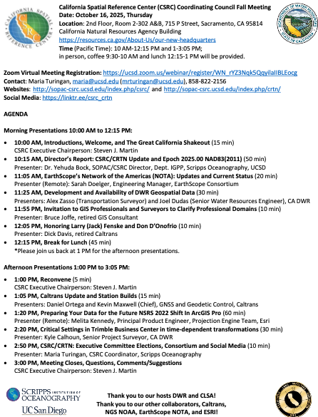
The CSRC holds Coordinating Council meetings to review CSRC activities and related state surveying and mapping efforts. The box titled “CSRC Coordinating Council 2025 Fall Meeting” lists the agenda for the most recent meeting. I attend these meetings virtually; they are consistently informative and I enjoy participating.
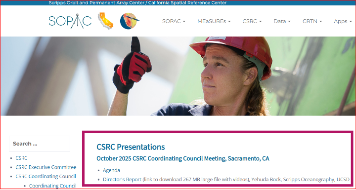
Dr. Yehuda Bock’s Director’s Report (SOPAC/CSRC Director, Dept. IGPP, Scripps Oceanography, UCSD) is available for download from the CSRC website: http://sopac-csrc.ucsd.edu/index.php/csrc-presentations/ (note: large file). At the Fall Coordinating Council Meeting Yehuda opened with a presentation on the new California Spatial Reference Network, CSRN Epoch 2025.00. I encourage readers to download the presentation or read my September GPS World newsletter, which highlighted CSRN Epoch 2025.00. This newsletter will focus on the Geodetic Program at Scripps Institution of Oceanography (SIO).
In my November 2023 GPS World newsletter, I noted NGS’s announcement of the NOAA FY23 Geospatial Modeling Competition awardees. In my March 2024 GPS World newsletter, I highlighted Scripps Institution of Oceanography’s (SIO) proposal. As noted there, Yehuda’s proposal included three activities:
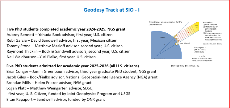
- Create a formal Geodesy Program at SIO to address the nationwide deficiency of geodesists. Expand current geophysics curriculum – funding for five graduate students.
- Develop an IFDM to supplement the NSRS for users in regions with significant ground motions, using GNSS and InSAR/GNSS displacement fields (funded by NASA projects) and underlying geophysical models. CSRC will exercise the IFDM through its community of public, private and academic users of precise spatial referencing in our challenging region of secular and transient crustal movements.
- Investigate a unified vertical reference frame, including a marine geoid optimized to be consistent with the full spectrum of observations from modern gravimetric geoids (e.g., GRAV-D, ICGEM), remotely sensed observations (e.g., SWOT, ICESat-2), in situ ocean observations and assimilating ocean models and the TRF.
At the Fall Coordinating Council Meeting, Yehuda provided an update on the status of the Geodesy Program at SIO. It was mentioned that some of the students are funded by the National Geodetic Survey (NGS)’s grant but others are funded by the National Geospatial-Intelligence Agency (NGA), United States Geological Survey (USGS), and the Office of Naval Research (ONR).
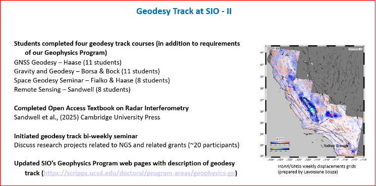
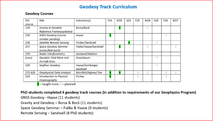
As mentioned in the Director’s report, they have initiated bi-weekly geodesy track seminars to discuss research projects related to NGS and other grants. Four videos by students discussing their projects were shown during Yehuda’s presentation.
The following are the titles and presenters of the four research projects:
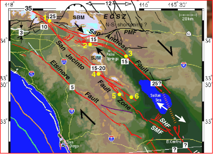
- San Jacinto Fault Zone by Neil Waldhausen
- Probing Antarctic basal ice state using airborne geodesy by Briar Conger
- Repeat Pass Interferometry by Rubi Garcia Gonzalez
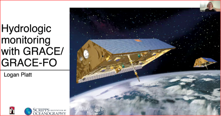
- Hydrologic monitoring with GRACE/GRACE-FO by Logan Platt
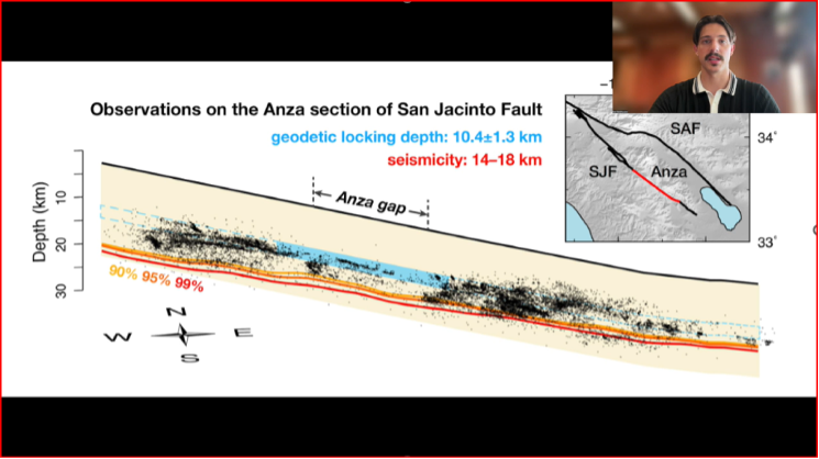
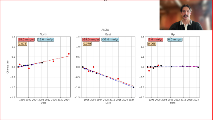
San Jacinto Fault Zone by Neil Waldhausen
I have included a few bullets summarizing their project and a few captured images from the videos. I would encourage everyone to download the presentation to listen to the short videos by these students. The presentations are only 90 seconds but are very interesting. Readers can contact the speakers through the University to find out more about their research.
Summary of the “San Jacinto Fault Zone” video:
- Neil uses GNSS to measure velocities and strain rates around the San Jacinto Fault.
- He focused on the Anza gap, a 20-km segment of the fault.
- He re-surveyed about 50 monuments that had been occupied over past decades.
- His work has lowered uncertainties in many site velocity measurements.
- His aim is to further reduce uncertainties in strain-rate and slip-rate estimates to better understand the Anza gap’s mechanics.
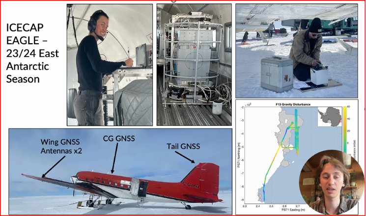
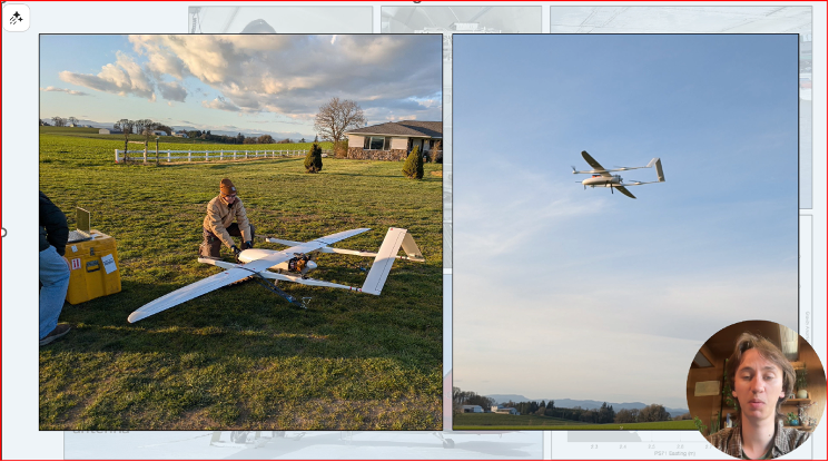
Summary of the “Probing Antarctic Basal Ice State Using Airborne Geodesy” video:
- Briar’s project uses gravity and radar data to study basal hydrology — water flow beneath glaciers and ice sheets, including subglacial lakes, channels, and pressure-driven water movement.
- He conducted fieldwork on the East Antarctic Ice Sheet during the 2023–24 season.
- He collected airborne gravity and GNSS data from a converted DC-3 aircraft.
- Data processing uses both PPP and differential positioning methods.
- His aim is to improve long-term sea-level rise predictions.
- He is also developing a fixed-wing UAV capable of collecting lidar, gravity, and photogrammetry data.
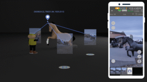
Probing Antarctic Basal Ice State Using Airborne Geodesy by Briar Conger
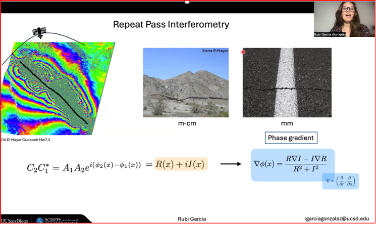
Summary of the “Repeat Pass Interferometry” video:
- Rubi used repeat-pass interferometry (phase gradient) to map small-scale surface deformation.
- The phase gradient is the change in interferometric phase between neighboring pixels; unlike the ambiguous single-pixel phase (wrapped within 2π), the gradient gives a continuous local rate of change useful for analysis.
- She compared fractures identified by phase-gradient analyses with historic fracture databases.
- Her ongoing work includes applying Andersonian faulting theory to assess whether fractures formed before or after earthquakes.
- Andersonian faulting (Anderson’s theory of faulting) is a geological framework for interpreting crustal stress and fault geometry; it’s used to interpret InSAR-measured deformation. While not a method of analysis for InSAR data itself, it serves as a critical interpretive tool for understanding the ground deformation patterns measured by InSAR.
Repeat Pass Interferometry by Rubi Garcia Gonzalez

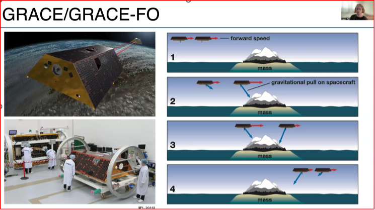
Summary of the “Hydrologic monitoring with GRACE/GRACE-FO” video:
- Logan described using satellite measurements of tiny changes in Earth’s gravity to track mass movement and better understand groundwater and the water cycle.
- He relied on GRACE and GRACE-FO data.
- The Gravity Recovery and Climate Experiment (GRACE) and its successor mission, GRACE-Follow On (GRACE-FO), are Earth-observation missions that use twin satellites to precisely map changes in Earth’s gravity field over time. This unique method allows scientists to track the movement of mass, primarily water, around the planet
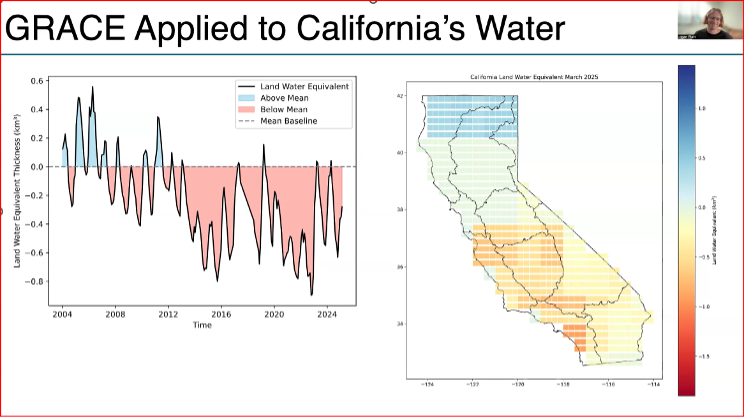
- He used the GRACE data to look at changes in California’s Water storage from 2004 to 2024.
- Results indicate a decline due to drought and heavy ground water usage, with more water being stored in northern California than southern California.
- This research supports water management, climate-change impact assessment, and strategies for sustainable groundwater use.
Hydrologic Monitoring with GRACE/GRACE-FO by Logan Platt
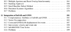
A new InSAR textbook, authored by several internationally recognized researchers, was also announced. Funded by the National Geodetic Survey and published Open Access, the book is available for free download. It’s a large file, but anyone working with InSAR data should obtain a copy.
New InSAR Textbook
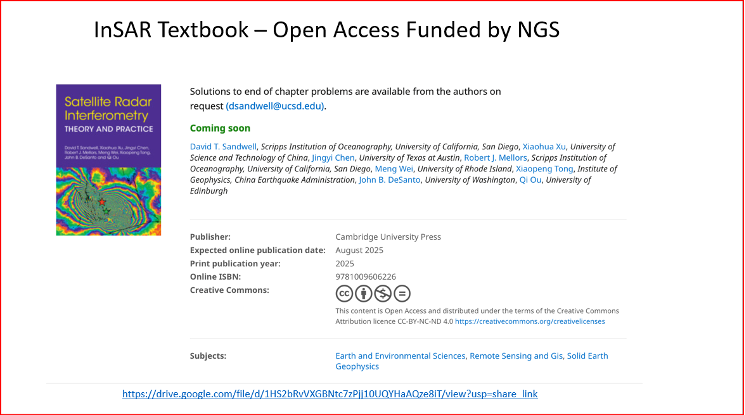
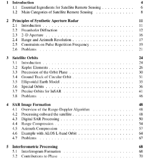
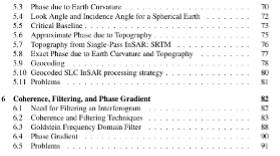
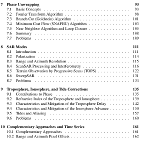
Table of Contents of New InSAR Textbook
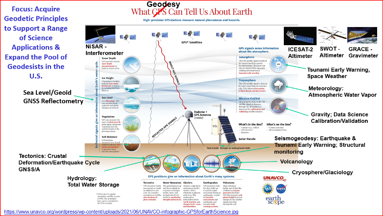
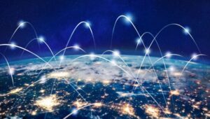
If you’ve read my newsletters, you know I’m passionate about advancing geodesy. I wanted to share one of Yehuda’s slides, “What Geodesy Can Tell Us About Earth,” because the four students are working on projects tied to real-world problems. The slide highlights geodesy’s importance and the many professions that rely on its findings.