No audio available for this content.
The April 25 magnitude 7.8 earthquake in Nepal created waves of energy that penetrated into Earth’s upper atmosphere in the vicinity of Nepal, disturbing the distribution of electrons in the ionosphere. These disturbances were monitored using GPS signals received by a science-quality GPS receiver in Tibet, a neighboring region to Nepal.
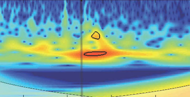
The data show that after the initial earthquake rupture (indicated by the vertical black line on the graphic), it took about 21 minutes for the earthquake-generated ionospheric disturbance to reach a GPS station (LHAZ) about 400 miles (640 kilometers) away from the epicenter in Lhasa, Tibet, China.
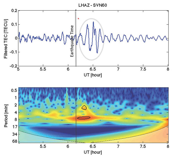
The disturbance measurements, known as vertical total electron content (VTEC) (depicted in blue in the upper panel), have been filtered using processing software developed by NASA’s Jet Propulsion Laboratory in Pasadena, Calif., to show wave-like disturbances (circled in red) in the distribution of electrons in the ionosphere. The waves have periods of between two and eight minutes in length. The disturbance measurements following the earthquake rupture are circled in black in the lower panel. The colors represent the relative strengths of the earthquake-induced ionospheric disturbances as captured by the GPS signals, with red being high and blue being low.
Attila Komjathy, a principal investigator of the Ionospheric and Atmospheric Remote Sensing group at JPL and adjunct professor at the University of New Brunswick, is leading this effort. Komjathy is also a GPS World annual award winner and named a Fellow of the Institute of Navigation in January.
The LHAZ GPS station is hosted at the Tibet Autonomous Regional Bureau of Surveying and Mapping Institute. The site collects both GPS and GLONASS (the Russian global navigation satellite system) data at a rate of 1 Hertz and is part of the International GPS Service (IGS).
Scientists study ionosphere-based measurements caused by natural hazards such as earthquakes, volcanic eruptions and tsunamis to better understand wave propagation in the upper atmosphere.The ionosphere is a region of Earth’s upper atmosphere located from about 37 miles (60 kilometers) to 621 miles (1,000 kilometers) above Earth’s surface.
The disturbances caused by earthquakes help scientists develop new first-principle-based wave propagation models. These models may become part of future early warning systems for tsunamis and other difficult-to-detect natural hazards.
The data is available on this FTP site.


William K.
It would be quite educational to have some explanation as to the nature of the mechanism that caused the disturbance, that is, what sort of energy did the earthquake release that led to the changes in the distribution of ions, (electrons)?
Attila
Dear William,
Thanks for the question.
The sudden, piston-like motion of the Earth’s surface such as the earthquake on Apr 25 in Nepal, creates atmospheric acoustic-gravity waves. Due to the exponential decrease in air density with height in the atmosphere, the wave amplitude increases exponentially as they propagate towards the ionosphere. There, the atmospheric (neutral) waves set the plasma into motion that in turn induces perturbations in electron density [e.g., Rolland et al., 2013]. There is a direct link through dynamic coupling between energy of ground (e.g., earthquakes) or ocean surface displacements (e.g., tsunamis) and the disturbances seen in the atmosphere [Meng et al., 2014].
The ionospheric perturbations induced by acoustic and gravity waves generated in the neutral atmosphere and ionosphere may be observed using GPS measurements with very high precision data processing techniques. Events on Earth’s surface or in the atmosphere, such as earthquakes, tsunamis, asteroid impacts, space shuttle launches, and large explosions are all potential sources of ionospheric disturbances [e.g., Komjathy et al., 2012 and Yang et al., 2014].
As an example, our narrated animation may be accessed investigating the 2011 Tohoku-oki earthquake-generated TEC disturbances:
https://www.youtube.com/watch?v=iR6ZfG1gAms
Best regards,
Attila Komjathy
NASA JPL
References:
Komjathy, A., D.A. Galvan, P. Stephens, M.D. Butala, V. Akopian, B.D. Wilson, O. Verkhoglyadova, A.J. Mannucci, and M. Hickey (2012). “Detecting Ionospheric TEC Perturbations Caused by Natural Hazards Using a Global Network of GPS Receivers: the Tohoku Case Study.” Earth, Planets and Space, Special Issue on “The 2011 Tohoku Earthquake” Vol. 64, pp. 1287–1294, 2012, doi:10.5047/eps.2012.08.003. http://link.springer.com/article/10.5047%2Feps.2012.08.003#page-1
Meng, X., A. Komjathy, O.P. Verkhoglyadova, Y.-M. Yang, Y. Deng and A.J. Mannucci (2014). “Coupling Tsunamis with the Ionosphere: A New Modeling Approach” Presented at the American Geophysical Union Fall Meeting, San Francisco, December 15-19.
https://www.dropbox.com/s/og5maaq1sedu4vv/MengAGUPosterCoupledModeling2014.png?dl=0
Rolland, L. M., M. Vergnolle, J.-M. Nocquet, A. Sladen, J.-X. Dessa, F. Tavakoli, H. R. Nankali, and F. Cappa (2013). Discriminating the tectonic and non-tectonic contributions in the ionospheric signature of the 2011, Mw7.1, dip-slip Van earthquake, Eastern Turkey, Geophys. Res. Lett., 40, 2518–2522, doi:10.1002/ grl.50544.http://onlinelibrary.wiley.com/doi/10.1002/grl.50544/abstract
Yang, Y.-M., A. Komjathy, R. B. Langley, P. Vergados, M. D. Butala, and A. J. Mannucci (2014). The 2013 Chelyabinsk meteor ionospheric impact studied using GPS measurements, Radio Sci., 49, doi:10.1002/2013RS005344. http://onlinelibrary.wiley.com/doi/10.1002/2013RS005344/abstract
G.W. Kafka
Riiiiight. So these events are disturbing the ionosphere… and you’re tracking them so you can make early prediction models. How would watching the ionosphere help If it’s only effected AFTER the event.
Seems unlikely. Unless you’re watching the ionosphere to see if anyone is playing their HAARP… but f the proles.
Attila
Dear G.F. Kafka,
Thanks for the comment.
These measurements help us develop new first principle-based wave propagation models for future early warning systems of tsunamis and other difficult-to-detect natural hazards. These model developments are not meant to “predict” earthquakes at all.
There exists however a group of international scientists actively working on ionospheric precursors of earthquakes. The potential physical mechanisms for any precursory activity in the ionosphere is very different from what may have caused the ionospheric signal we showed in this article.
Regards,
Attila Komjathy
NASA JPL
G.W. Kafka
Thanks for the reply.
So a NASA scientist is admitting there are physical mechanisms that disturb the ionosphere is such a way as to be precursory to earthquakes?
Am I reading that correctly? Because that is kind of a big deal. I mean I see your word potential in there… and no mention of HAARP devices… but still… if there are international scientists working on it…
What exactly are the physical mechanisms we are talking about? Potentially of course.
Attila
Dear G.W. Kafka,
There is a large body of work in the scientific literature describing potential physical mechanisms for ionospheric precursors. One of the more credible ones is by
Kuo, C. L., J. D. Huba, G. Joyce, and L. C. Lee (2011), Ionosphere plasma bubbles and density variations induced by pre-earthquake rock currents and associated surface charges, J. Geophys. Res., 116, A10317, doi:10.1029/2011JA016628.
Others are disputing such claims including myself:
Thomas, J. N., J. J. Love, A. Komjathy, O. P. Verkhoglyadova,M. Butala, and N. Rivera (2012), On the reported ionospheric precursor of the 1999 Hector Mine, California earthquake, Geophys. Res. Lett., 39, L06302, doi:10.1029/2012GL051022
Hope this is useful.
Regards,
Attila Komjathy
NASA JPL
Davor
I remember reading in ancient Jyotish text that mentioned some special clouds that form as precursors of earthquakes. These measurements found disturbances after the earthquake. To me both the observations are equally interesting, as both are incredible, yet we too often discard ancient seers as unreliable at best.
Attila
Dear Davor,
Interesting! In addition, animal behavior and earthquake prediction studies have been widely reported. USGS has some theories listed on their website [google for “USGS Animals & Earthquake Prediction”].
Regards,
Attila Komjathy
NASA JPL
Serge Plattard
Dear Attila,
I still miss some points in the previous discussion.
Based on the results presented in the article, I can understand that similar detection could be used for a tsunami early warning because the tsunamis can propagate on very long distances (e.g. December 2004), so detection of a VEC change can be used to issue warnings covering a very large region of interest.
In the case of an earthquake, It can only be told AFTER. It it’s BEFORE the full quake takes place, then it’s another mechanisms than the one described in the paper.
And this is what we would very much would like to read about about. Not just references, but a description understandable by some of us with an educated background in physics.
Of course, based on these ionospheric perturbations, probably impossible to come up with a precise location of tha quake, or the likelihood as to where the tsunami might hit. Right?
Regards,
Serge
Attila
Dear Serge,
I agree with you that detection of VTEC changes generated by tsunamis is feasible. Actually, it is currently being considered for operational tsunami early warning systems.
Yes, the article only discusses acoustic signatures in the ionosphere AFTER the earthquake.
You are asking me about mechanism BEFORE the earthquake. We do not research the topic nor do I believe personally that the described mechanisms have been fully validated. However, here is a possible mechanism described in the peer-reviewed literature by non-JPL researchers:
“Pre-earthquake signals have been widely reported, including perturbations in the ionosphere. These precursory signals, though highly diverse, may be caused by just one underlying physical process: activation of highly mobile electronic charge carriers in rocks that are subjected to ever increasing levels of stress. The charge carriers are defect electrons associated with O in a matrix of O2. Known as positive holes, they flow out of the stressed rock into the unstressed rock volume, traveling meters in the laboratory, probably kilometers in the field. At the rock–air interface they cause: (i) positive surface potential, (ii) field-ionization of air molecules, (iii) corona discharges. The rate of formation of airborne ions can exceed 109 cm-2 s-1. Massive air ionization prior to major earthquakes increases the electrical conductivity in the air column and may cause ionospheric perturbations, earthquake lights, and unusual animal behavior as well as infrared emission.”
If you are interested in the article please send me an email request and will send it to you (my JPL email is easy to find).
Regards,
Attila Komjathy
NASA JPL
Attila
Dear Serge,
I missed one of your last comments. Sorry.
“Of course, based on these ionospheric perturbations, probably impossible to come up with a precise location of tha quake, or the likelihood as to where the tsunami might hit. Right?”
We can not estimate the location of the earthquake based on the TEC perturbations. However, based on the TEC perturbations, it is highly feasible to estimate where and when the tsunami waves might hit. We did a simulation for this based on the 1964 Alaska earthquake:
https://www.youtube.com/watch?v=3m0l5bmA8-k
Here is description:
Tsunami arrival warning products based on GPS observations of ionospheric total electron content (TEC) disturbances generated by the tsunami waves (simulations). We expect to start generating early warning messages about 90 minutes prior to the tsunami waves reaching the CONUS region as the current distribution of PBO stations located at the CONUS region will start tracking ionospheric TEC perturbations generated by the tsunami waves at low elevation angle satellites (at 10 degrees or so). As the TEC perturbations propagate towards the shores more GPS satellites at higher elevation angles will join in tracking these TEC signatures, thereby reducing the error bars associated with the arrival time of the tsunami. Here we demonstrate our potential capabilities in protecting the CONUS region using GPS/ionosphere observations.
The transparent color background represents the TEC perturbations generated by the JPL-modified coupled ocean-thermosphere-ionosphere GITM Model. The color-coded simulated data points indicate TEC perturbations at each IPP locations assuming a current distribution of the PBO stations. This is to indicate that using the real-time PBO-stations-collected ionospheric observations may be successfully used to detect tsunami waves arriving at the U.S. West Coast following the 1964 earthquake and ensuing tsunami. The black triangles display the current distribution of the GPS stations as part of the PBO network. Red colored squares are DART buoy locations. The advantage of the GPS-ionosphere based detection system is that GPS satellites at low elevation angles may detect the oncoming tsunami about 90 minutes prior to the tsunami waves reaching the coast line. The epicenter of the 1964 earthquake is also shown with the red circle.”
Regards,
Attila Komjathy
NASA JPL
Felipe Narváez M.
Doctors have very good morning researchers GPS WORLD.com
My name is Philip Narvaez, student Ingeniría Electronics
the National University of Colombia at Manizales Caldas;
My Thesis is based on applying an algorithm to measure the entropy data, (FOR THE STUDY OF SEISMIC PRECURSORS)
graphics that were constructed: (lhaz-SVN60), its
ARTICLE: GPS Data Show How Nepal Quake Disturbed Earth’s Upper Atmosphere.
At the bottom of article there is a link where you will find the database taken by the GPS but which was not all that used to create graphs of the article.
I would appreciate, if I provide data with which were built graphic, that is, the data vectors for the coordinate axes (x) and (Y). To plot them back into MATLAB, in advance I say that this information I’m asking you is for academic and nonprofit and respect their copyright and prodiedad thereof, as well as generate a literature reference for the group of investigfadores GPSWORLD.com on proprietary information.
Thank you very much for your attention, I hope your prompt response!
Attila
Dear Felipe,
Please contact me directly using my work email to discuss this further. No other data was used to generate the plots other than the RINEX files that you will find a link for in the original post.
Regards,
Attila Komjathy
NASA JPL
Felipe Narváez M.
Thank you doctor for answering my concern,
which is not your mail.
I apologize because I native language is not English
then sometimes I misspelled.
This is my email: pfnarvaezm@unal.edu.co
you can send me an email and from there I give
all information about my thesis.
Thank you.