No audio available for this content.
GPS World contributing editor Eric Gakstatter gave a talk on predicted ephemeris at the Civil GPS Service Interface Committee (CGSIC) on Tuesday. The talk was invited and the topic was suggested by CGSIC coordinators. The 53rd meeting of the CGSIC was held Monday and Tuesday before the Institute of Navigation GNSS+ 2013 Conference. Here is Eric’s talk:
Whenever I point a critical finger at the GPS folks, I apologize before I do so because it’s really a wonderful system.
What I try to offer the community in general is a link between the GPS system operators and the civil community. It’s amazing when you think about it, two huge user bases of civil and military users, and a little strip called CGSIC that communicates between them. Rick [Hamilton of CGSIC] introduced me to this concept a couple months ago and asked me to investigate it and think about it. This is what I researched and talked to some folks and came up with.
First, I want to introduce you to some folks doing fascinating things with GPS.
Here’s a young company, Geoloqi, doing really interesting things in Portland. They don’t have any clue where GPS came from; they just have it on their smartphones. One of the founders collected GPS data everywhere he went for the last three and a half years. This map shows 2.5 million data points, and I think it’s fascinating.
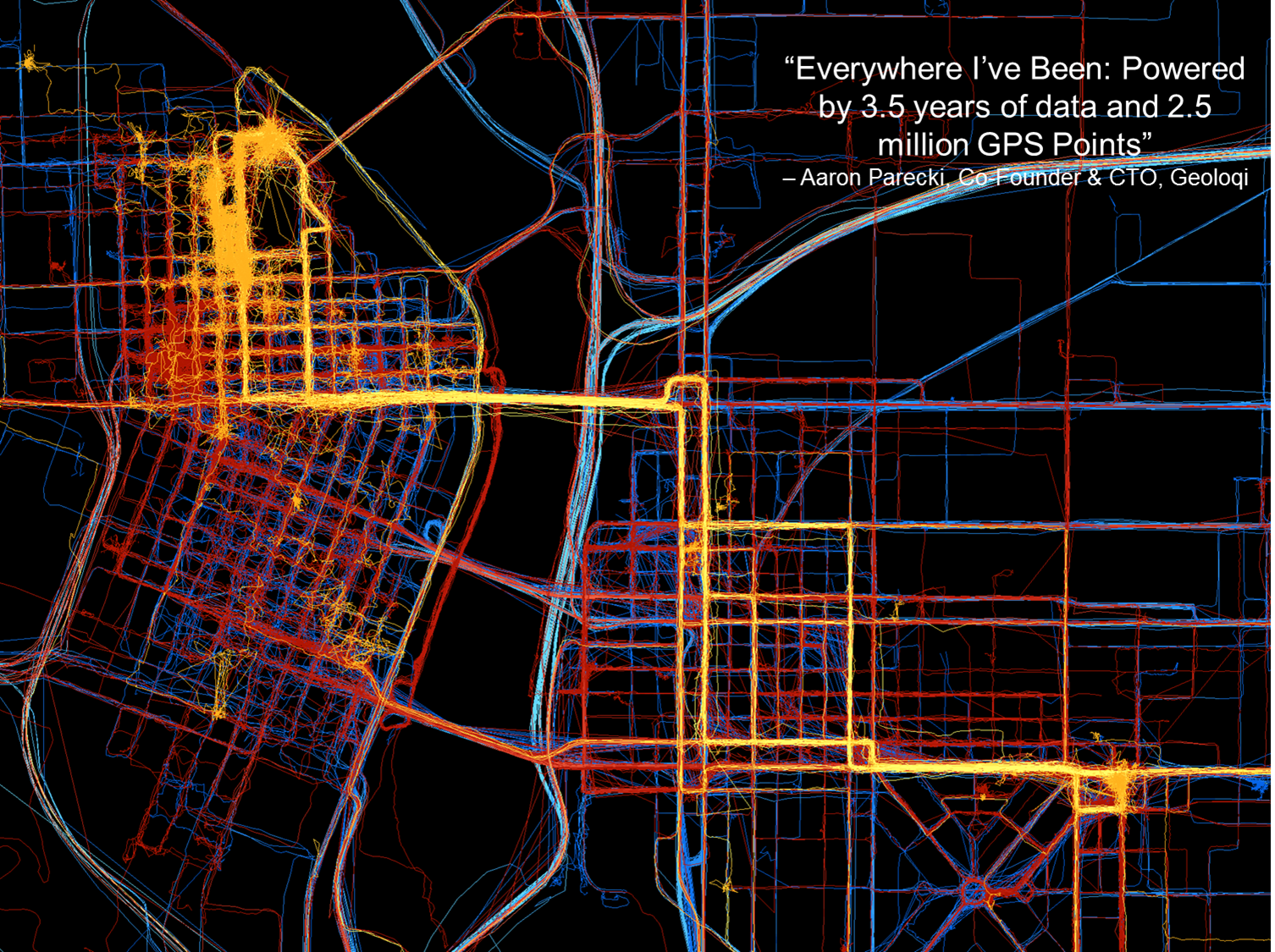
These folks interface between the GPS chipset in the mobile device and the apps that run on it. They sold their company to Esri last year.
“Geolocation has the potential to become an indispensable part of our lives. But to be a valuable service, the technology needs to be invisible yet opted into, private, and secure.” — Amber Case, Geoloqi founder
These kids just want to get things done, create ideas and create products: things like, check into a hotel when you get within 100 yards of the door; get your prescription prepared and ready for you when you come within a certain distance of a pharmacy. All these kinds of things are based on the geotrigger or geofence concept.
Now, talking about my work, primarily in surveying and mapping, with companies like utilities with 15 million customers and a lot of infrastructure. To put that at the fingertips of a maintenance person, that’s pretty amazing. I’ve been swimming in this soup for a long time, and I hadn’t heard of this concept — the predicted ephemeris (PRED) produced by GPSOC.
Take a PRED state vector data file, which is currently generated every 15 minutes by the GPS Operations Center under For Official Use Only (FOUO), currently designated unclassified, but not accessible to the general public. If it were made available for public use, it could decrease time to first fix from 40 seconds when you turn on your mobile device, to 5 to 10 seconds.
In the high-precision field like mine, surveying, it really doesn’t make too much difference because by the time you get out of your truck and set up your gear, 30 seconds has already gone by and it doesn’t make much difference.
Now it could be more of an issue with mobile devices in GPS-impaired environments such as urban canyons or indoor environments, where 30 seconds could make the difference between getting a fix or not.
If predicted ephemeris were available, developers could distribute it terrestrially via a wireless network to mobile devices.
Problem: How to transfer PRED from a U.S. government FOUO environment to make it available to application developers?
To me as a product developer or a product manager, interested in pushing products out to the community, that’s a really small speed bump. But when I talk to colleagues who operate in that (government) space, that’s a significant undertaking, a real obstacle. We’re talking about a big change, and a big process to go through to effect that change.
PRED from the horse’s mouth, so to speak, from the U.S. Air Force, really builds credibility. I can build it into a product, because I know it’s going to be there three or four or more years from now.
PRED can be made available, but Civil GPS app developers need to speak up — because civil users won’t. They don’t know about it. They don’t know what is possible.
“How does somebody know what they want if they haven’t even seen it?” — Steve Jobs
I’m trying to raise awareness here. I’ll probably write about soon in the magazine or in my [Survey Scene] email newsletter.
Frank van Diggelen, Broadcom. We’ve been doing this in the commercial world for over a decade. You all have it in your cellphones, with about 90% likelihood provided by Broadcom or someone who’s licensed our patents. It doesn’t work properly unless you have the source of the data and the client side working very cooperatively. The issue is the . . . gap between prediction and use. If the satellite is moved (in orbit or clock) then the prediction is wrong, and you need client-side software that is design cooperatively with the predictions. Our predictions are available in 2-, 4-, 7- or 30- day intervals. Think of a use case where you get a seven-day prediction, and then go away from network coverage for several days, meanwhile, say on Day 4, a satellite is moved or has its clock adjusted, on Day 5 it is set healthy, on Day 6 you turn on your handset and use the prediction from six days ago — it will be wrong and your client-side software has to catch that and know know how to invalidate the predictions.
We deliver these orbital predictions at about the rate of a billion per month. It’s been there for 10 years, and its been working so well most people aren’t even aware that it’s there. If the Air Force puts these out, that sounds great, but if you don’t have client-side software looking for erroneous predicitions — when a satellite is adjusted or moved — then things would be a lot worse for the user community than they have for the last 10 years.
Eric Gakstatter: I understand that, but that’s true for any technology. If a company implements it incorrectly, the market will reject it. Let the market decide.
There may be a need for a non-proprietary solution (PRED) that is publicly available so it could be implemented by other developers, and level the playing field to increase market adoption of GPS.


Adrian Stimpson
Frank, good comments. Erik – please drop by our (Rx Networks) booth at ION. We provide extended ephemeris to over 700 million smartphones a week (as well as other devices) and have been doing this for many years. We would be happy to chat about the successes and the challenges of deploying extended ephemeris in the market.
Rich Lee
Eric,
Thanks for your focus on this topic. As I spontaneously indicated to your audience at the conference Tuesday, I felt need to address the premises by you and others who commented about the open availability and benefits of predicted ephemeris.
There indeed are commercial sources for predicted ephemeris that are not proprietary or exclusive to a single chip supplier. A leading supplier of such open solutions is RX Networks. They have supplied high reliability assistance and augmentation data products and services for years. This include long term ephemeris prediction solutions for networked and autonomous devices. I believe its safe to say their solutions for extended ephemeris are featured in more brands of mobile devices than any other source.
RX has advanced algorithms and methods for the fusion of GPS and WiFi observables that improve mobile GPS performance and user experience.
I appreciate your focus on this subject since mobile GPS would not have reached its success without advanced prediction (including its extension to autonomous devices such as PNDs) and use of hybrid (WiFi) methods. Without these techniques, mobile GPS encountered poor yields, long delays in times to fix, and very often led to a disappointing user experience.
Rich Lee
Francis Yuen
Eric, thanks for the great article on how Predicted Ephemeris (aka Extended Ephemeris) work.
As Frank said, the source data that contains the predicted ephemeris must work closely with the client-side software for the whole system to work. It is also important to understand the source data file size for a typical 28 days prediction is nearly 7 MB for GPS constellation alone. Some kind of compression technique must therefore be used to compress this data to a much smaller data file size in order for it to be transmitted from the prediction server to a mobile device efficiently and without impacting the battery life. Specifically, the client-side software must use very little CPU/Memory resources of the mobile device, be fast to decompress the source data and compute a solution, provide excellent accuracy up to 28 days and be a small executable code.
Although our extended ephemeris service is new to the market, we have developed a proprietary clock model to significantly improve the prediction performance to a level that was previously not achievable before. If the GPSOC, the Air Force or any organizations around the world choose to make their source data available, we would warmly welcome and incorporate them into what we already have to add value to that data and enhance our own performance and integrity even more.
Francis Yuen, Baseband Technologies Inc.
Eric Gakstatter
Thanks for your comments. During my presentation, I probably should have mentioned (if I didn’t) that there’s a number of commercial solutions available for predicted ephemeris. The purpose of my presentation was to raise awareness and gauge interest in the commercial demand for predicted ephemeris from the GPSOC, which is being generated but not available to the public yet.
Les Leonard
I do not understand the recommendation here. It appears the author believes GPS in phones take many seconds to start tracking. Assisted GPS has been the standard for all major carriers for many years. It has the best of both worlds. the device subsystem gets the quickstart data it needs and no very large files have to be distributed. Check out the OMA SUPL standards.
Eric Gakstatter
I didn’t intend to make a recommendation in the article, but rather raise awareness of the potential. I realize there are proprietary solutions for predicted ephemeris data. The idea is that the US Gov’t could make available predicted ephemeris accessible by anyone. It would be an “authoritative” source and might help propagate the use of predicted ephemeris in markets other than those served today by the proprietary solutions.