No audio available for this content.

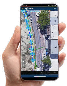
Esri has debuted ArcGIS Indoors, which is designed to enable interactive indoor mapping of corporate facilities, retail and commercial locations, airports, hospitals, event venues, universities and more.
According to Esri, the solution applies the latest location technology to allow users to see and share where assets, rooms, departure gates and offices are located.
ArcGIS Indoors uses data streams, real-time processing and location intelligence tools to help businesses and other organizations understand how to better coordinate space and other resources with their facilities and campuses. Insights from sensor networks deliver real-time information to managers and executives through interactive dashboards, while visitors and employees can find useful information about the buildings they occupy, the company said.
The solutions also allows users to quickly access and explore critical business information, such as the location and status of fire extinguishers and their last inspection dates.
“ArcGIS Indoors brings the interior building space into the future by placing data about employees, schedules, meetings, customers and events into a geographic context,” said Nitin Bajaj, product manager at Esri. “Having spatial awareness gives executives, managers and employees better insight so they can operate more efficiently and competitively.”
According to Esri, ArcGIS Indoors will be available for widespread use by the end of 2018. In addition, a beta version of the product will be released at this year’s Esri User Conference, taking place July 9-13 at the San Diego Convention Center in San Diego, California.


Ben Banda
Dear Sir/Madam
I wish to become a partner/dealer for your products.
May you please guide me
Many Thanks
Ben Banda
+263772698585
Ben Banda
Dear Sir/Madam
I wish to become a partner/dealer for your products.
May you please guide me
Many Thanks
Ben Banda
+263772698585
Lorena
An outstanding share! I’ve just forwarded this onto a colleague who was
doing a little research on this. And he actually ordered me lunch because
I found it for him… lol. So allow me to reword this….
Thank YOU for the meal!! But yeah, thanx for
spending some time to talk about this issue here
on your website.